Forestry Data Analysis
Introduction
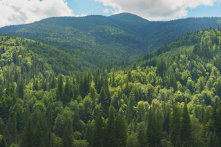
Forests are among Earth’s most vital ecosystems providing oxygen, storing carbon, protecting biodiversity, and supporting livelihoods for millions. Yet, as climate change, deforestation, and land degradation accelerate, the need for data-driven decision-making in forestry has never been more urgent. This is where forestry data analysis comes in.
By applying modern analytical methods, from statistics and machine learning to GIS and remote sensing, researchers and managers can quantify forest dynamics, model growth patterns, and predict the impacts of human and natural disturbances.
In this article, we’ll explore what forestry data analysis entails, why it matters, how it’s applied, and where you can learn to do it effectively.
What is Forestry Data Analysis?
Forestry data analysis involves collecting, processing, and interpreting quantitative information about forests to inform management, conservation, and policy decisions.
Data sources in forestry typically include:
- Field measurements: Tree diameters, heights, species, and density.
- Remote sensing data: Satellite imagery (e.g., Landsat, Sentinel, MODIS), LiDAR, and UAV data.
- Environmental variables: Climate, soil type, elevation, and human pressure.
- Socio-economic data: Land ownership, land use history, and policy context.
Analysts integrate these datasets to monitor forest change, estimate biomass, detect disturbances, and model ecosystem processes across scales, from local stands to entire biomes.
Why Forestry Data Analysis Matters
1. Improving Forest Management
Modern forestry moves beyond traditional inventories. Data analysis supports precision forestry — where decisions are tailored to site-specific conditions using models and maps derived from data.
Example: Predicting optimal thinning intensity based on stand structure and growth models.
2. Supporting Conservation and Climate Action
Forests are central to the global carbon cycle. Analyzing carbon stocks, sequestration potential, and forest degradation helps countries meet commitments under the Paris Agreement and REDD+ frameworks.
Example: Modeling carbon sequestration potential using forest biomass and soil carbon data.
3. Assessing Disturbance and Recovery
Through time-series analysis, researchers track post-fire recovery, disease outbreaks, and deforestation trends, supporting proactive interventions.
Example: Using Sentinel-2 imagery and the Normalized Burn Ratio (NBR) to monitor vegetation regrowth after wildfires.
4. Driving Policy and Community Awareness
Reliable forest data allows policymakers to design evidence-based interventions and empowers local communities to manage their forest resources sustainably.
Tools and Techniques Used in Forestry Data Analysis
Forestry data analysis is a multidisciplinary field that blends ecology, statistics, GIS, and computer science. Below are common tools and methods:
| Category | Example Tools | Application |
|---|---|---|
| GIS and Remote Sensing | QGIS, ArcGIS, Google Earth Engine | Mapping and spatial analysis |
| Programming and Statistics | R, Python | Modeling, visualization, and data automation |
| Machine Learning | Random Forest, XGBoost, CNNs | Predicting forest types, biomass, or disturbance |
| Spatial Analysis | GDAL, sf, raster (R packages) | Managing and analyzing spatial data |
| Visualization | ggplot2, Leaflet, Plotly | Creating maps and interactive dashboards |